
June 27, 2026|CoreSignal
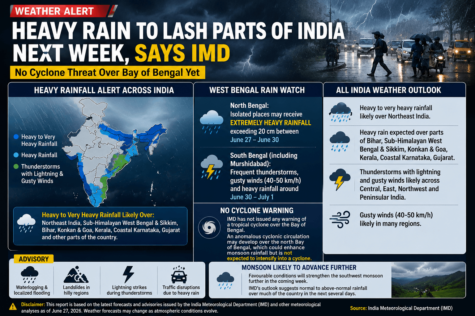
Thank you for reading this post, don't forget to subscribe!Kolkata/New Delhi: The India Meteorological Department (IMD) has forecast an active phase of the southwest monsoon over large parts of the country during the coming week, with heavy to very heavy rainfall expected across eastern and northeastern India. Among the states likely to experience the greatest impact is West Bengal, where both the northern Himalayan districts and several southern districts are expected to receive widespread rainfall accompanied by thunderstorms and gusty winds.
The latest weather outlook indicates that while a cyclonic circulation may develop over the north Bay of Bengal, there is currently no indication of a tropical cyclone forming. Meteorologists say the developing weather system is likely to strengthen the monsoon flow, resulting in enhanced rainfall rather than cyclonic activity.
No Cyclone Over Bay of Bengal Despite Online Speculation
In recent days, social media posts have claimed that a powerful cyclone could form over the Bay of Bengal. However, the IMD has not issued any cyclone watch or warning for the region.
Instead, weather experts are monitoring a cyclonic circulation over the north Bay of Bengal, a common monsoon feature that often intensifies rainfall over eastern India. Such circulations help transport moisture inland but do not necessarily evolve into tropical cyclones.
At present, all official forecasts suggest that the primary concern for eastern India is heavy rainfall and thunderstorms, not a cyclone.
North Bengal Faces Risk of Extremely Heavy Rainfall
According to the IMD’s latest forecast, North Bengal is expected to receive the most significant rainfall during the current monsoon spell.

Districts including:
- Darjeeling
- Kalimpong
- Jalpaiguri
- Alipurduar
- Cooch Behar
may witness heavy to very heavy rainfall, with isolated locations likely to receive more than 20 centimetres of rain between June 27 and June 30.
The continuous rainfall may trigger:
- Landslides in hilly areas
- Flash floods in low-lying regions
- Rising river levels
- Disruption of road transport
- Temporary suspension of tourism activities in vulnerable areas
Authorities are expected to remain on alert, particularly in landslide-prone stretches of the Darjeeling hills.
South Bengal Also Under Rain Watch
While North Bengal is likely to bear the brunt of the monsoon activity, South Bengal is also expected to experience an active spell of weather over the coming days.
Districts such as:
- Kolkata
- Howrah
- Hooghly
- North 24 Parganas
- South 24 Parganas
- Nadia
- Murshidabad
- East Burdwan
- West Burdwan
- Birbhum
- Purba Medinipur
- Paschim Medinipur
are likely to witness:
- Frequent thunderstorms
- Moderate to heavy rainfall
- Lightning activity
- Gusty winds reaching 40–50 km/h
- Temporary waterlogging in urban areas
For Murshidabad, forecasts indicate repeated spells of rain beginning late June and continuing into early July, with locally heavy showers possible around June 30 and July 1.
Kolkata May See Intermittent Heavy Showers
Residents of Kolkata can expect cloudy skies throughout the week, with intermittent rainfall becoming more frequent during afternoon and evening hours.
Heavy showers may lead to:
- Traffic congestion
- Waterlogging on major roads
- Slower suburban train and bus services
- Reduced visibility during peak commuting hours
Municipal authorities are expected to monitor drainage systems closely as rainfall intensity increases.
Monsoon Strengthening Across Eastern India
Meteorologists say the southwest monsoon is likely to strengthen further due to favourable atmospheric conditions over the Bay of Bengal.
A moisture-laden southwesterly wind pattern, combined with the developing cyclonic circulation, is expected to deliver sustained rainfall across:
- West Bengal
- Bihar
- Jharkhand
- Odisha
- Assam
- Meghalaya
- Arunachal Pradesh
- Sikkim
This pattern is typical of an active monsoon phase and is expected to continue into early July.
Heavy Rainfall Expected in Several Other States
Beyond West Bengal, the IMD has forecast heavy rainfall over several parts of India.
Regions likely to be affected include:
- Northeast India
- Bihar
- Sub-Himalayan West Bengal and Sikkim
- Konkan and Goa
- Gujarat
- Kerala
- Coastal Karnataka
Meanwhile, thunderstorms accompanied by lightning and gusty winds are expected across many parts of central, northwestern, eastern and peninsular India.
Agriculture May Benefit, But Risks Remain
The expected rainfall is likely to benefit agriculture by improving soil moisture and supporting paddy transplantation across many districts.
However, excessive rainfall could also pose challenges such as:
- Crop damage due to waterlogging
- Riverbank erosion
- Localised flooding
- Delays in harvesting of early-season crops
- Damage to rural roads
Farmers are advised to monitor district-level weather bulletins and take necessary precautions where heavy rainfall is forecast.
Public Advisory
The IMD has advised residents in rain-affected districts to remain cautious during the active monsoon spell.
People are encouraged to:
- Avoid unnecessary travel during heavy downpours.
- Stay away from rivers, canals and waterlogged areas.
- Take shelter indoors during thunderstorms.
- Avoid standing beneath isolated trees or electric poles during lightning.
- Follow updates issued by district administrations and disaster management authorities.
- Secure loose outdoor objects in areas experiencing strong winds.
Tourists travelling to the Darjeeling hills and other mountainous regions should check local weather conditions before planning their journey.
Outlook for the Coming Week
Weather models suggest that the active monsoon phase may persist through the first week of July. While rainfall distribution will vary from district to district, eastern India—including West Bengal—is expected to remain under cloudy skies with recurring spells of rain and thunderstorms.
As of now, there is no official forecast indicating the development of a cyclone over the Bay of Bengal. The focus remains on heavy monsoon rainfall and associated hazards such as flooding, waterlogging and lightning.
Disclaimer
This report is based on the latest forecasts and advisories issued by the India Meteorological Department (IMD) and other recognised meteorological agencies as of June 27, 2026. Weather conditions can change rapidly, and readers are advised to follow official IMD updates and local administration advisories for the latest information.






One Comment